Wednesday, February 20, 2019

Khunjerab Pass


Khunjerab Pass (elevation 4,880 metres or 16,010 feet) is a high mountain pass in the Karakoram Mountains in a strategic position on the northern border of Pakistan (Region of Gilgit–Baltistan’s Hunza and NagarDistricts) and on the southwest border of China (the Xinjiang region)

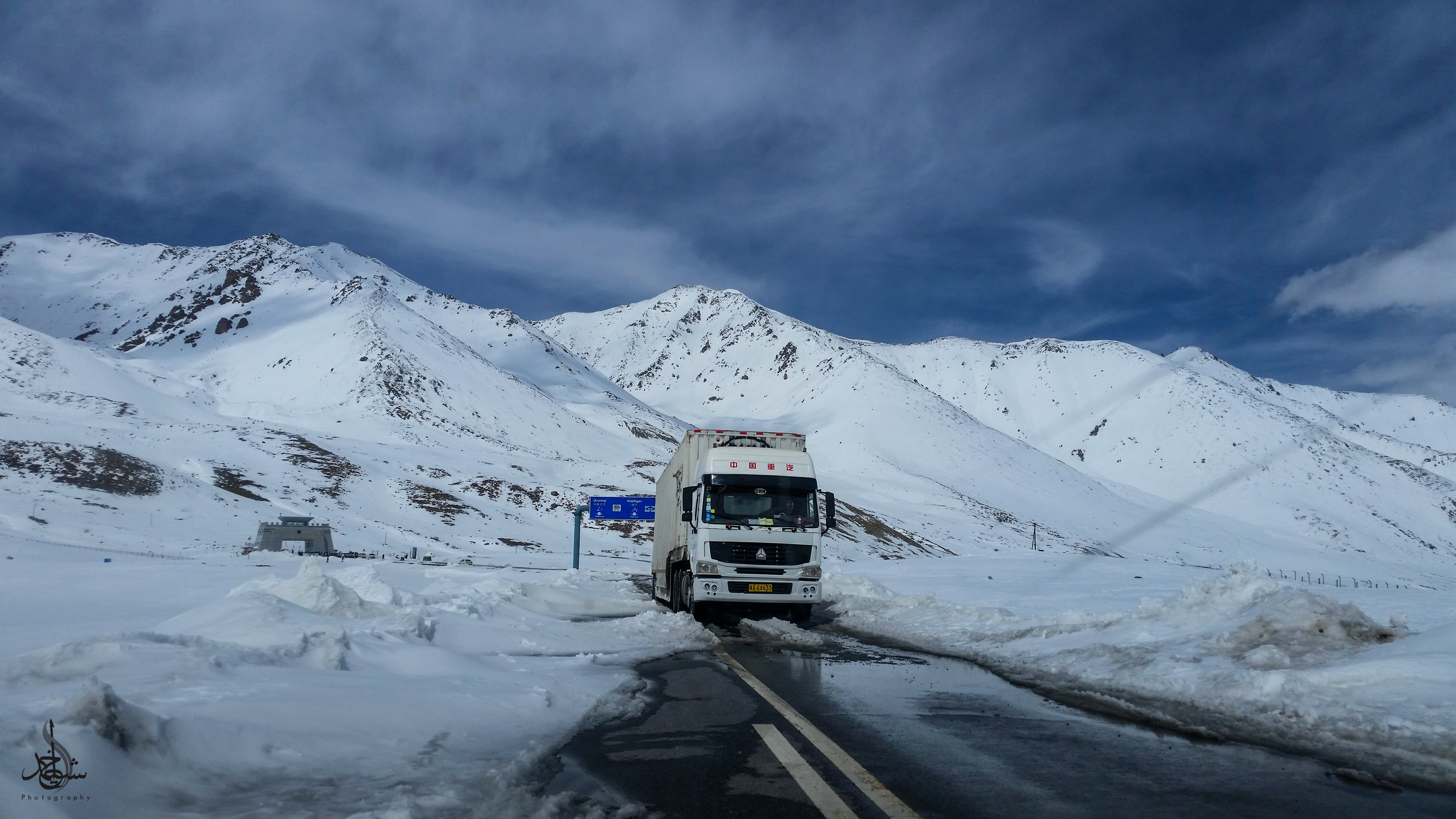
A truck parked on the roadside near Pakistan-China border. — Photo by Jamil Nagri
 
Khunjerab Pass, the highest border on earth, on their own vehicle using Karakoram Highway (N35), the eighth wonder of the world and one of the highest paved international roads in the world. Khunjerab Pass at an altitude of 16,002 ft. Travel on G.T Road toward Peshawar and after crossing Tool Plaza and then at Abbottabad Mor take a right turn and you will be on Karakoram Highway that is going directly to Khunjerab Pass. One thing to know is that the Karakoram Highway from Besham toward Chillas is in very bad condition and you also have to wait for conveying before crossing that section of KKH. Good thing is that there is an alternate route which is short and much better, is Mansehra-Naran-Babusar-Chillas Highway. From Mansehra, you have to leave KKH and take the route to Naran and then to Babusar Pass which will lead you to Chillas and from Chillas you will be again on KKH and go toward Gilgit. 


Now that you know that the driving distances from Abbottabad to Khunjerab Pass is 631.9 km, would you like to view a more detailed map? Well there are a few different ones that you can view which provide a bird's eye view of the terrain on the road map from Abbottabad to Khunjerab Pass.

Aside from time, the "cost" of the trip should be taken into consideration as well since it's just as important as time, and to do so you can calculate the fuel cost from Abbottabad to Khunjerab Pass. Afterwards, you may want to start planning your road trip. Need directions? You can view turn by turn driving directions from Abbottabad to Khunjerab Pass. Can your vehicle make the climb to Khunjerab Pass? Check the route elevation from Abbottabad to Khunjerab Pass.

Located in Gircha, Khunjerab Hotel Sost features a garden and terrace. Boasting a 24-hour front desk, this property also provides guests with a restaurant. Free WiFi is available. A continental breakfast is available every morning at the property. Hotel Rs 2950/=


Boasting a garden, Sarai Silk Route is set in Hunza. With free WiFi, this 3-star hotel offers a 24-hour front desk. Guests can make use of a terrace. The units in the hotel are equipped with a flat-screen TV. All rooms are fitted with a private bath. Hotel Rs 1320/=


Situated in Gulmit, Gulmit Tourist Inn features a garden and a terrace. Boasting a 24-hour front desk, this property also provides guests with a restaurant. The accommodation provides room service and free WiFi. At the hotel, each room has a wardrob Hotel Rs. 1700/= 

Sunday, December 3, 2017

SHADRA AZAD KASHMIR

Related image

SHADRA.
Sharda (Also known as Shardi ) is a small town in Neelam District in Azad KashmirPakistan. It is one of the two tehsils of Neelum district, and is reputed to be the most beautiful spot of the Neelum valley. It is located on the banks of the Neelum river at an altitude of 1981m, about 136 kilometers Northeast of Muzaffarabad.


The ruins of the famous temple and Hindu pilgrimage site Sharada Peeth, dedicated to the goddess Sharada who represents learning, is situated in this town. Other historical sites in the town include the Sharda fort, and Kishan Ghaati. Sharda and Nardi are two mountain peaks overlooking Sharda in the valley. It was a Buddhist and Hindu place of learning for centuries. The Sharada script was developed here in the 9th century.


TRANSPORT/ACCOMM DATION.
Sharda is accessible by Neelam road from Muzaffarabad. Buses run daily between Muzaffarabad and Sharda in good weather. The town has a rest house and a youth hostel of AJK Tourism and Archeology Department for tourists stay. Few private hotels are also located here.


BEST HOTEL IN SHADRA NEELUM VALLEY.
Book best hotels in Sharda Neelum Valley,2 hotels are best one is Neelum star river ... Book yourhotel in sharda at discounted rates. sharda kashmir lodges. Neelum Star Guest House Sharda is best hotel in Sharda for those who ... Kashmir Lodges has two branches in Sharda, one is located on bank of river just 2km. Hotel Neelum GreenLand. Neelum Valley Road, Keran, Pakistan. Neelum Star River Guest House.Neelum valley road, Sharda, Pakistan. Kashmir Sharda View Guest House. Sharda Bazar, Sharda, Pakistan. Oriental View guest house. Main Road, Kel, Pakistan. Pirzada Noman Guest House. Mountain View Guest House.

1)           Wadi Resort.
2)           Neelum Valley Hotel.
3)           Shadra Heights Hotel


TRANSPORT ISLAMABAD TO SHADRA.
From Islamabad.. take a coaster from Faizaabad Skyways to ... Muzaffarabad to Kel buses ply all the day.. from early morning to 8 or 9pm. And many transport service are available. 


Thursday, September 14, 2017

Merksem Antwerp


History.

The history of Merksem goes back to Gallo-Roman times. During that period the region was mentioned as Merk (border) andHeim (settlement) being part of the diocese Kamerijk. Merksem has for centuries been part of a larger community together with Schoten and Sint-Job-in-'t-Goor. During the Spanish period Merksem used to be a Heerlijheid, a known Lord of Merksem is Anthony van Stralen. In the 16th century Merksem was separated from Schoten.


The road currently known as Bredabaan (Breda Road), once a major northern access to Antwerp, begins in Merksem and goes up north, all the way up until the border with the Netherlands. It ends in the Dutch city of Breda (hence the name). Other major axes would include Lambrechtshoekenlaan, Groenendaallaan, Maantjessteenweg and Ringlaan. Together with Bredabaan they could be considered as the boundaries of the centre of Merksem. Another main axis, that constitutes most of the southern border of the district, is a canal called the Albert Canal, which connects the Port of Antwerp to the river Meuse near Liège and is an important connection for inland freight shipping.


Antwerp ,DutchAntwerpen is a Flemish city in Belgium, the capital of Antwerp province in the community of Flanders. With a population of 510,610, it is the most populous city proper in Belgium. Its metropolitan area houses around 1,200,000 people, which is second behind Brussels. Antwerp is on the River Scheldt, linked to the North Sea by the Westerschelde estuary. It is about 40 kilometres north from Brussels, and about 15 kilometres from the Dutch border. The Port of Antwerp is one of the biggest in the world, ranking second in Europe and within the top 20 globallyAntwerp was also the place of the world's oldest stock exchange building, originally built in 1531 and re-built in 1872, it has been derelict since 1997. 

Antwerp has long been an important city in the Low Countries, both economically and culturally, especially before the Spanish Fury (1576) in the Dutch Revolt. The inhabitants of Antwerp are nicknamed Sinjoren, after the Spanish honorific señor or Frenchseigneur, "lord", referring to the Spanish noblemen who ruled the city in the 17th century. Today Antwerp is a major trade and cultural centre, and is the world's second most multi-cultural city (after Amsterdam) home to 170 nationalities. It is also known as the "diamond capital" of the world for its large diamond district. 


Buildings and landmarks.

In the 16th century, Antwerp was noted for the wealth of its citizens Antwerpia nummis. The houses of these wealthy merchants and manufacturers have been preserved throughout the city. However, fire has destroyed several old buildings, such as the house of the Hanseatic League on the northern quays, in 1891. During World War II, the city also suffered considerable damage by V-bombs, and in recent years, other noteworthy buildings were demolished for new developments. Antwerp City Hall dates from 1565, and is a Belfry in Renaissance style.

Antwerp City Hall at the Grote Markt(Main Square).

16th-century Guildhouses at theGrote Markt.

The Onze-Lieve-Vrouwekathedraal(Cathedral of our Lady), here seen from the Groenplaats, is the tallest cathedralin the Low Countries and home to several triptychs by Baroque painterRubens. It remains the tallest building in the city.

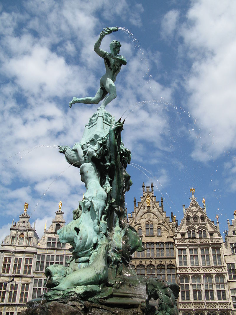
Statue of Brabo and the giant's hand

Fort of Antwearp.

Antwerp was formerly a fortified city, hardly anything remains of the former enceinte, only some remains of the city wall can be seen near the Vleeshuis museum at the corner of Bloedberg and Burchtgracht. A replica of a castle named Steen has been partly rebuilt near the Scheldt-quais in the 19th century. Antwerp's development as a fortified city is documented between the 10th and the 20th century. The fortifications were developed in different phases:10th century fortification of the wharf with a wall and a ditch, 12th and 13th century canals (so called "vlieten" and "ruien") were made, 16th century. Spanish fortifications. 19th century double ring of Brialmont forts around the city, dismantling of the Spanish fortifications.  20th century 1960 dismantling of the inner ring of forts, decommissioning of the outer ring of forts.

Transportation

A six-lane motorway bypass encircles much of the city centre and runs through the urban residential area of Antwerp. Known locally as the "Ring" it offers motorway connections to Brussels, Hasselt and Liège, Ghent, Lille and Bruges and Breda and Bergen op Zoom (Netherlands). The banks of the Scheldt are linked by three road tunnels (in order of construction): the Waasland Tunnel (1934), the Kennedy Tunnel (1967) and the Liefkenshoek Tunnel (1991).
Daily congestion on the Ring led to a fourth high-volume highway link called the being proposed. It would have entailed the construction of a long viaduct and bridge (the Lange Wapper) over the docks on the north side of the city in combination with the widening of the existing motorway into a 14-lane motorway; these plans were eventually rejected in a 2009 public referendum.
In September 2010 the Flemish Government decided to replace the bridge by a series of tunnels. There are ideas to cover the Ring in a similar way as happened around Paris, Hamburg, Madrid and other cities. This would reconnect the city with its suburbs and would provide development opportunities to accommodate part of the foreseen population growth in Antwerp which currently are not possible because of the pollution and noise generated by the traffic on the Ring. An old plan to build an R2 outer ring road outside the built up urban area around the Antwerp agglomeration for port related traffic and transit traffic never materialized.
Motorway bypass

Rail

Antwerp is the focus of lines to the north to Essen and the Netherlands, east to Turnhout, south to Mechelen, Brussels and Charleroi, and southwest to Ghent and Ostend. It is served by international trains to Amsterdam and Paris, and national trains to Ghent, Bruges, Ostend,BrusselsCharleroiHasseltLiègeLeuven and Turnhout.
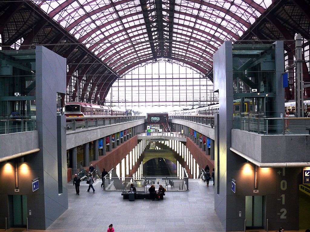
Antwerp Central station is an architectural monument in itself, and is mentioned in W G Sebald's haunting novel Austerlitz. Prior to the completion in 2007 of a tunnel that runs northwards under the city centre to emerge at the old Antwerp Dam station, Central was a terminus. Trains from Brussels to the Netherlands had to either reverse at Central or call only at Berchem station, 2 kilometres (1 mile) to the south, and then describe a semicircle to the east, round the Singel. Now, they call at the new lower level of the station before continuing in the same direction.
Railway Station Antwerp.

Antwerp International Airport.

A small airport, Antwerp International Airport, is located in the district of Deurne, with passenger service to various European destinations. A bus service connects the airport to the city centre.
The now defunct VLM Airlines had its head office on the grounds of Antwerp International Airport. This office is also CityJet's Antwerp office. When VG Airlines (Delsey Airlines) existed, its head office was located in the district of Merksem. Belgium's major international airport, Brussels Airport is about 45 kilometres from the city of Antwerp, and connects the city worldwide. It is connected to the city centre by bus, and also by train. The new Diabolo rail connection provides a direct fast train connection between Antwerp and Brussels Airport as of the summer of 2012. There is also a direct rail service between Antwerp (calling at Central and Berchem stations) and Charleroi South station, with a connecting buslink to Brussels South Charleroi Airport, which runs twice every hour (on working days).

Antwerp International Airport.

Antwerp Airport


Friday, May 13, 2016

MULTAN

MULTAN


Multan pronunciation is a city in Punjab, Pakistan. It is Pakistan's 5th most populous city and has an area of 133 square kilometres (51 sq mi). The city is located on the banks of the Chenab River.


Multan is known as the City of Sufis or City of Saints and Madinat-ul-Auliya because of the large number of shrines and Sufi saints from the city. The city is blanketed with bazaars, mosques, shrines, and ornate tombs. It is the birthplace of Fariduddin Ganjshakar (popularly known as "Baba Farid"), recognised as the first major poet of the Punjabi language. Multan is located in a bend created by five rivers of central Pakistan.

The Sutlej River separates it from Bahawalpur and the Chenab River from Muzaffar Garh. One of the oldest Cities in the world dating back 6000 years, the city has grown to become an influential political and economical centre for the country, with a dry port and excellent transport links. Multan is famous for its crops: wheat, cotton and sugar canemangoescitrusguavas, andpomegranates.

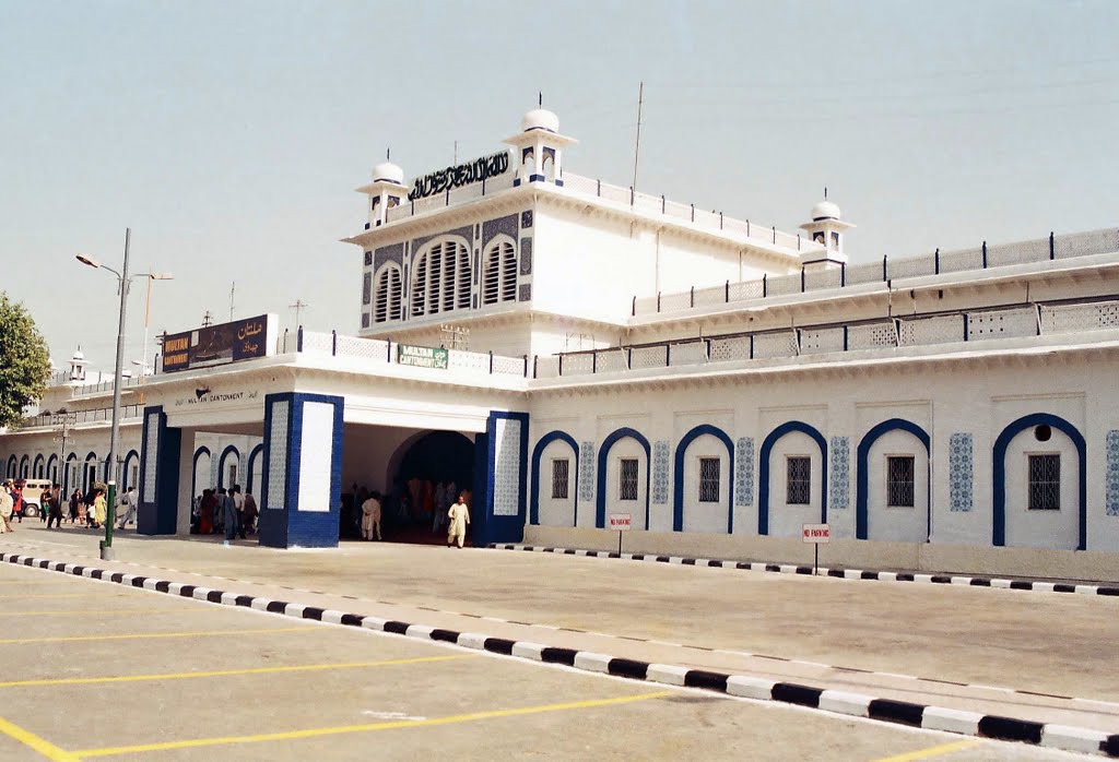
Multan Railways Station


Railways

Multan is connected by rail with all parts of the country and lies on the main track between Karachi, Peshawar, Lahore andQuetta. The main Peshawar-Karachi railway line passes through Multan district. The district then links trains to nearby districts of Khanewal, Lodhran and Muzafargarh districts through the railway network.[28] Multan Cantonment railway stationis the main railway station of Multan.

Airport.


Airport.


Multan International Airport is an airport situated 10 km away from the city centre of Multan. It is the largest airport in South Punjab and it operates to cater mainly to the population of Multan, VehariKhanewalMuzaffargarhRajanpurSahiwal, andPakpattan to mainly to other points within Pakistan as well as the Middle East. Flights are currently operated by the national flag carrier, Pakistan International AirlinesQatar Airways and Emirates Airlines. However, since the growth of air travel within the region, there has been speculated interest from other private carriers. The rise in air-travel has also led to the expansion of the current airport with a new runway and a large new terminal.


Shah Shams Park, Multan.

Shah Shams Park is located on Eidgah Road near Tomb of Shah Shams, Multan, Pakistan. It's a beautiful park created on the named of famous sufi saint Shah Shams Tabrez. Shah Shams Park is having lots of attractions, flowers, fountains, green courts and much more. They also have a playing area having small lake and different rides for children's and all family members.Address: Located on Eidgah Road near Tomb of Shah Shams, Multan, Pakistan


Education.

In 1950, then-Governor Abdur Rub Nishtar founded Nishtar Medical College. Doctor graduates of this institution have spread across the world, and many have become established names in the field of medicine. The new Nishtar Institute of Dentistry provides dental and surgical services to Multan and the adjoining cities. The pioneer Punjab Government-chartered Institute of Southern Punjab Multan is the 2nd largest institute in Multan and third largest in South Punjab. It was the first Education Institute in Punjab, and is the only private institute recognised by HEC in Multan.

Multan Public School & College is a public institution in Multan City for providing quality education to the students of Multan as well as the other southern backward areas of Multan. Multan Public School, known as a Divisional Public School, provides boarding facilities for the students of far-flung areas. Multan Public School has a fleet of Hino Buses for pick and drop of the students.
Air University Multan is a leading Public sector University providing state of the art Higher Education at affordable fee. Air University Multan Campus AUMC has established new standards of Excellence in Academia in southern Punjab with diverse culture of Research & Development in Science & Technology. Pakistan Institute of Engineering and Technology (PIET) is the new engineering college in Multan. It offers BSc Electrical, Civil and Mechanical engineering.


Bahauddin Zakariya University (formerly known as Multan University) is the main source of higher education for this region. The Swedish Institute of Technology in Multan is a campus of the Swedish Group of Technical Institutes, the largest private-sector organisation providing technical education and vocational training in the Punjab. Multan Medical and Dental College is the only private medical institution in Southern Punjab. Now more universities from federal are also opening campuses in Multan, such as AIR university, NUML (National University of Modern Languages), and MMDC (Multan Medical and Dental College), a private medical college. The Government High School Rid, Moza Rid, Chk 2 Faiz Multan is affiliated to BISE Multan and shows satisfactory results at secondary education level.